 Delete: Deletes the selected feature.
Note
Deleted features can be restored. See Info Bar for more information.
 Edit: This functionality exists for LINES or AREAS only.
Lines: Either end of the line can be moved. Tracing a line intersecting the existing line 2 times will replace that section of the line with your new geometry.
Areas: Tracing a line intersecting the existing area 2 times will replace that section of the area with your new geometry. You can cut or add area.
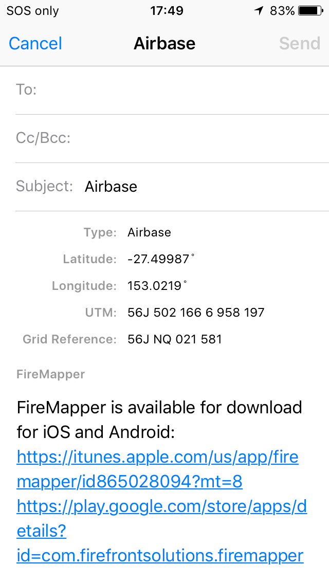
 Email: Sends the selected feature as an email message.
The email message includes a screenshot of the map and any GPS photos that are attached to the selected feature if available.
This option is available for all map features. You can set the default email addresses for email messages in the Main Menu->User Profile.
Email: Sends the selected feature as an email message.
The email message includes a screenshot of the map and any GPS photos that are attached to the selected feature if available.
This option is available for all map features. You can set the default email addresses for email messages in the Main Menu->User Profile.
Note
On iOS devices, this uses the Apple email client. You will need to have your email
account configured in it for this to work.
 Text: Sends the selected feature as a text message.
The text message includes a screenshot of the map and any GPS photos that are attached to the selected feature if available.
This option is available for all map features. You can set the default mobile numbers for text messages in the Main Menu->User Profile.
Text: Sends the selected feature as a text message.
The text message includes a screenshot of the map and any GPS photos that are attached to the selected feature if available.
This option is available for all map features. You can set the default mobile numbers for text messages in the Main Menu->User Profile.
 Rotate: Rotates the selected point by 45 degrees.
This option is only available for directional point types (eg. fire/wind direction).
Rotate: Rotates the selected point by 45 degrees.
This option is only available for directional point types (eg. fire/wind direction).
 Flip: Flips the selected line style.
This option is only available for asymmetrical lines (eg. control lines, backburns).
Flip: Flips the selected line style.
This option is only available for asymmetrical lines (eg. control lines, backburns).
 Directions: Opens the selected location with a navigation application.
These applications are supported:
Directions: Opens the selected location with a navigation application.
These applications are supported:
Google Maps (turn by turn navigation software)
Apple Maps (turn by turn navigation software, iOS only)
Open Street Maps (mapping website)
Waze Maps (turn by turn navigation software)
Flight Radar24 (flight tracking software)
Windy (weather)
Foreflight (aviation/flight planning software, iOS only)
OzRunways (aviation/flight planning software, iOS only)
 Navigate With FireMapper: Navigates in a straight line to the selected point in FireMapper.
The button will point in the direction of the selected feature using the internal compass. This is handy if you need to know the approximate
direction of the feature on the map without having to start a navigation.
Navigate With FireMapper: Navigates in a straight line to the selected point in FireMapper.
The button will point in the direction of the selected feature using the internal compass. This is handy if you need to know the approximate
direction of the feature on the map without having to start a navigation.
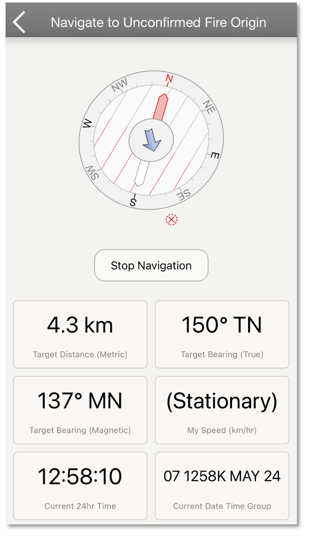
Note
This functionally is not available yet on the Android.
 Sync Feature: Shares the selected feature on the map.
This button is only available for features that have not been shared yet. If the map is currently a private map the map
will be converted into a shared map (however only the selected feature will be shared). You can share all features on the
map via the Map Export Screen.
Sync Feature: Shares the selected feature on the map.
This button is only available for features that have not been shared yet. If the map is currently a private map the map
will be converted into a shared map (however only the selected feature will be shared). You can share all features on the
map via the Map Export Screen.